Milo, the Mila Fully Autonomous Indoor/Outdoor Robotic Guide Dog
Demos
Indoor navigation
Indoor obstacle course
Outdoor navigation
Outdoor nav with pedestrian avoidance (drone view)
How Milo sees the world
Milo builds a live 3D understanding of its surroundings from LiDAR and camera: occupied space, walkable floor, people, and the handler—then navigates through that map with a simulator-trained policy.
drag to orbit · scroll to zoom
- robot
- handler
- obstacles
- walkable path
- objects
- pedestrian
Abstract
Many Blind and Low-Vision (BLV) people rely on guide dogs for moment-to-moment navigation, such as staying on path and avoiding obstacles and pedestrians. However, guide dogs are expensive to acquire and maintain (approximately $50k USD plus ongoing costs), often involve long waiting lists, and have relatively short life expectancies. While robot guide dogs offer a promising alternative, existing approaches exploring this idea suffer from several drawbacks: They often lack the autonomy required for real-world deployment, relying on prior 3D scans of the environment, external computation, or limited awareness of the handler.
In this work, we present Milo, the first open-source, low-cost (approximately $2k USD) robotic guide dog platform capable of fulfilling the basic collaborative navigation role expected of a guide dog. Milo is fully autonomous, requiring no a priori knowledge of the environment, completely self-contained with all computation performed onboard, and suitable for both indoor and outdoor navigation while avoiding obstacles and pedestrians. Our system consists of a modified Unitree Go2 robot (equipped with onboard compute, sensors, and a handle), a perception stack combining voxel mapping with floor, obstacle, and pedestrian detection, and a navigation stack based on an obstacle-avoidance policy trained in a custom bird’s-eye-view simulator. We evaluate Milo in real indoor and outdoor obstacle courses and compare it against a costmap-based baseline, demonstrating smoother navigation and fewer handler collisions. To maximize accessibility for BLV users, we release both the robot hardware instructions and the complete software stack as open source.
Comparison with Prior Work
| Method | Indoor & Outdoor | Unknown Environment | Fully Onboard | Handler Commands | Dynamic Handler Modeling | Open Source |
|---|---|---|---|---|---|---|
| Sorokin et al. | Outdoor only | ✓ | ✓ | ✗ | ✗ | ✗ |
| Cai et al., “RDog” | ✓ | ✗ | ✓ | ✓ | Partial | ✗ |
| Hwang et al., “Summer” | Indoor only | ✓ | ✗ | ✓ | Static | ✗ |
| Hwang et al., “GuideNav” | Outdoor only | ✗ | ✓ | ✗ | ✗ | ✓ |
| Ours, “Milo” | ✓ | ✓ | ✓ | ✓ | ✓ | ✓ |
Video
Figures
-
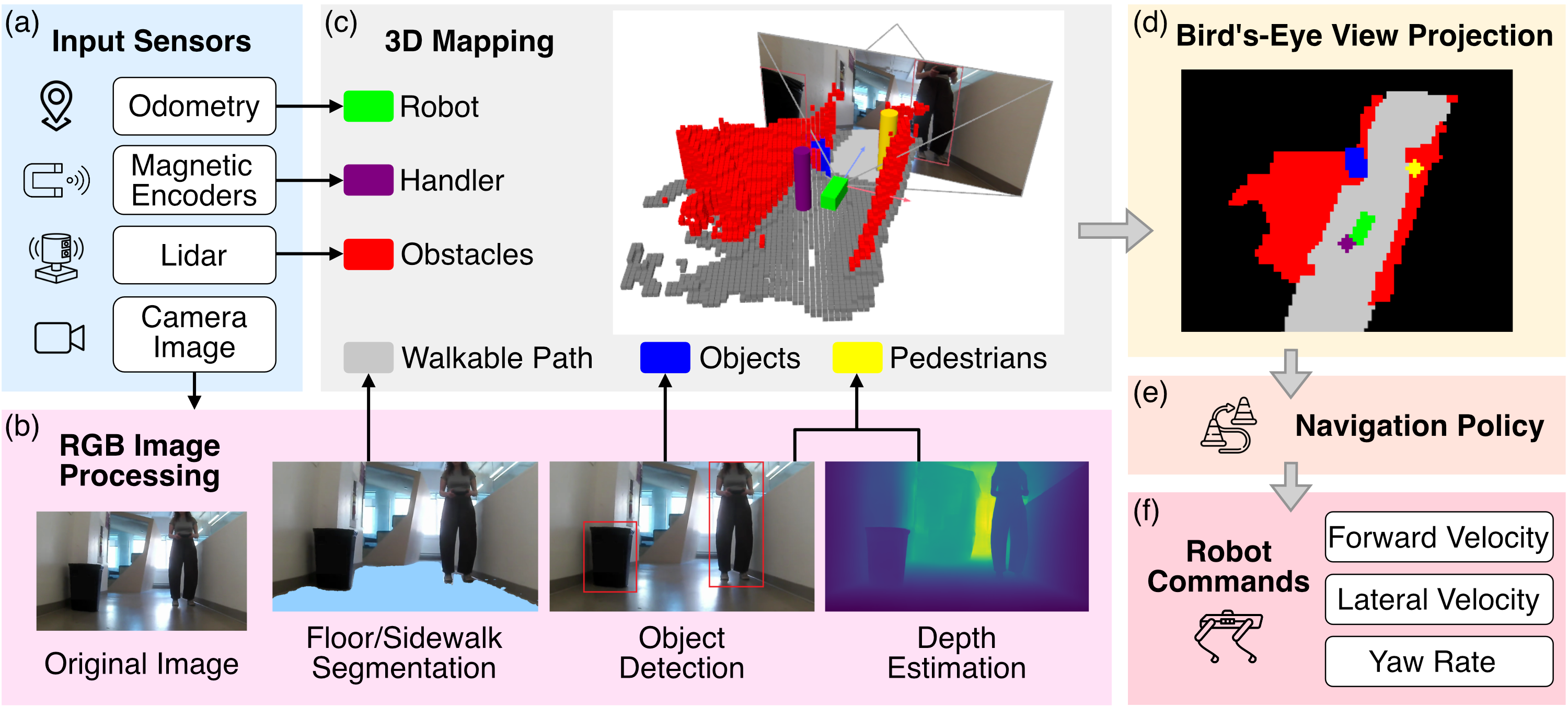
(a) RGB images, LiDAR scans, odometry, and handle encoder measurements are acquired.
(b) RGB images are processed to segment the walkable path and detect objects and pedestrians, while depth estimation updates pedestrian positions.
(c) The segmented path, detected objects and pedestrians, the robot and handler states, and LiDAR data are fused into a voxel-based 3D map.
(d) The voxel map is converted into a bird's-eye-view (BEV) representation.
(e) The BEV map is provided to the trained navigation policy, which predicts the robot's linear velocity and yaw rate commands.
(f) The predicted commands are filtered by a local obstacle avoidance safety module before being sent to the robot.
-
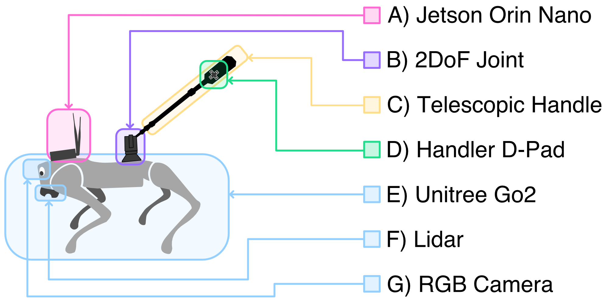
(A) The Nvidia Jetson Orin Nano runs navigation and perception systems;
(B) the 2 degree-of-freedom joint is equipped with magnetic encoders that sense the handler's position with respect to the dog;
(C) the telescopic handle is adjustable to cater to different handler heights and preferences;
(D) with the 5-way directional pad, the handler can start/stop the robot, indicate faster/slower walk speed, and desire to turn at the next opportunity;
(E) the whole system is based on a Unitree Go2 Air/Pro robot dog, utilizing its...
(F) LiDAR and...
(G) front-facing RGB camera.